
Page 21 - journal_2016_december_uploaded_2022_mar_16
P. 21
SLN 9
MARINE POLLUTION & ENVIRONMENTAL DAMAGE IN THE GULF OF
MANNAR
Captain (H) KAPSK Kariyapperuma
“Humans simply take too much from their natural environment. Animals and plants
need to grow and breed. However, sometimes humans catch (or harvest) these animals and
plants before they have had time to breed and grow. When this happens repeatedly, there are
not enough to catch the next time. When too much is taken for too long, the end result is that
nothing or little is left. Perhaps the best example of overexploitation is the Pearl Fisheries of the
Gulf of Mannar.”
The Gulf of Mannar:
India
Sri Lanka
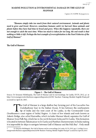
Figure 1 – The Gulf of Mannar
Source: Dr Siriyanie Miththapala, The Gulf of Mannar and its surroundings, Sir Lanka, IUCN, 2012, p.1 at
http://www.mangrovesforthefuture.orgassetsRepositoryGOM-Teachers-Training-Module-English-Final.pdf
accessed on April 20, 2015.
he Gulf of Mannar is a large shallow bay forming part of the Laccadive Sea
(Lakshadweep Sea) in the Indian Ocean. It lies between the southeastern
Ttip of India and the west coast of Sri Lanka, in the Coromandel Coast
(Southeastern coast region of India) Region. A chain of low islands and reefs known as
Adam’s Bridge, also called Ramsethu, which includes Mannar Island, separates the Gulf of
Mannar from Palk Bay, which lies to the north between India and Sri Lanka. This formation
is located in between Talaimannar in Sri Lanka and Pamban (Rameswaram) in India making
it is impossible for ships to navigate between Gulf of Mannar and the Palk Bay . Only small
1
1 Dr Siriyanie Miththapala, The Gulf of Mannar and its surroundings, Sir Lanka, IUCN, 2012, pp.1, 2 at http://www.
mangrovesforthefuture.orgassetsRepositoryGOM-Teachers-Training-Module-English-Final.pdf accessed on April 20, 2015.